


Introduction
Rainier Developments is preparing an outline planning application for up to 63 dwellings north of Rugby Road, Kilsby.
As well as providing 40% of homes as affordable housing, the proposals will create new public open space, enhance biodiversity and provide supporting infrastructure.
Before finalising and submitting an outline planning application to West Northamptonshire Council, Rainier is inviting the community to comment on the plans and share their feedback. On this website, you can find more details about the vision, emerging proposals read our handy FAQs and provide your feedback.
ABOUT RAINIER DEVELOPMENTS
Rainier Developments is a privately owned land and development company that work jointly with landowners, key stakeholders, local authorities and developers to create high-quality developments, built with both the present and future needs of local communities in mind.
Rainier has delivered projects throughout the Midlands and nationally and understands the importance of engaging with the local community and West Northamptonshire Council to understand the unique characteristics of the site and the needs of the Council. They are committed to making a positive contribution to Kilsby as a village and as a place to live.
How Can I Have My Say?
You can submit an online feedback form with your comments by clicking here. You can email the project team at contact@rainier-kilsby.co.uk You can Freephone 0808 1688 296 to leave a message and a member of the team will call you back.
Please submit your feedback by Friday 31st October, so that it can be considered before the plans are finalised and submitted as part of an outline planning application to West Northamptonshire Council.


Location & Background
The site is located on the northern edge of the village, which is situated approximately 7km southeast of Rugby, 8km northeast of Daventry and 21km northwest of Northampton.
The site currently comprises 6.07 hectares of pastoral land.
It is surrounded by other pastoral lands and existing residential development to the south.

Planning Context
What is an outline planning application?
An outline planning application seeks to agree the principle of development on a site, including the land use (in this case, residential), as well as identifying a masterplan for the proposed developable area. That’s why you may not see the level of detail in the plans you would expect. If an outline planning application is granted planning permission, this must be followed by a ‘reserved matters’ submission showing more detail, which will be determined separately by the Council.
As part of this outline planning application for up to 63 new homes, Rainier is seeking approval for the principle of development and access only. Permission for all other matters including layout, scale and appearance of the new homes, will be agreed with the Council through a further reserved matters application, which will also be subject to further consultation with all stakeholders.
Why does Kilsby need new homes?
West Northamptonshire Council is required to bring forward sites for housing to meet its needs, which is calculated based on housing demand and population statistics by the Ministry for Housing, Communities and Local Government. Currently, West Northamptonshire Council must meet an annual target of 2,515 new homes.
Kilsby is strategically located with access to the highway network, the A5 and M1, allowing for travel to nearby employment sites in Rugby, Daventry and Northampton. Additionally, the hourly bus service between Daventry and Rugby provides sustainable travel to amenities and services.
Vision & Key Development Principles
The site provides an opportunity to create a sustainable and attractive extension to the village, inspired by the context and local character of Kilsby, while protecting the open countryside and landscape setting.
Multifunctional Open Space
Future residents will benefit from well-located, high-quality, and attractive public spaces. These spaces will integrate the best examples of the ridge and furrow landscape, existing tree and hedgerow lines, attenuation features, swales, the existing Public Right of Way, a community orchard and an area of children’s play. A soft landscaped edge along the western and northern boundaries will provide a positive transition from the village to the surrounding countryside. Open spaces will have active frontages from adjacent buildings around the edges, providing activity, overlooking and encouraging social interaction. New and existing residents will also benefit from enhanced accessibility to the ridge and furrow landscape, strengthening the connection to this locally significant area.
Local Movement
Consistent with the characteristics of well-designed places, the movement network will give people a choice of direct and attractive walking and cycling links to nearby destinations. A clear hierarchy of streets and other routes will help people find their way around. The development will reinforce and extend the existing movement network via a vehicular access from Rugby Road, integration of the existing Public Right of Way crossing the site, and the provision of a new pedestrian connection to Rugby Road. A new leisure route along the northern edge of the site will increase public access to open space in the village and experience of the ridge and furrow landscape.
Placemaking
Buildings will have a positive and coherent identity that draws inspiration from the immediate and wider context to create an attractive, sustainable place to live. Houses along the northern and western edges will positively front the open spaces, offering pleasant views and natural surveillance of the public realm. The new play provision and the community orchard will create a new facilities for existing and future residents. Development will make efficient use of land as part of supporting local public transport, facilities and services, with the form and scale responding positively to the prevailing character of Kilsby and the ridge and furrow landscape.
-
.jpg)
Design Opportunities Plan (click to enlarge)
Emerging Proposals
Our emerging masterplan shows how we think the new homes, access routes and public open space could be delivered within the site.
We are still in the early design stage, and currently, our initial plans could provide:
- Up to 63 new homes, offering a range of dwelling types, sizes and tenures to help create an inclusive new community.
- A responsive design that reflects local distinctiveness and sits comfortably within the current vernacular and landscape context.
- Enhanced access to the Ridge and Furrow landscape via the proposed new leisure route and improved connection from the existing Public Right of Way.
- Homes built to Future Homes 2025 Standards.
- A sustainable development, responding to the core principles of the National Planning Policy Framework (NPPF) and national design guidelines.
- A site that is well connected and designed to encourage and support walking and cycling, with strong links to existing Public Rights of Way, local services and facilities.
- New play provision for the enjoyment of existing and future children, along with the creation of a new community orchard.
- A new landscape edge to the northern boundary will help to create a gradual transition from development to the surrounding countryside.
- Where possible, existing landscape features will be retained and enhanced within public open space to help development blend positively into the village and character of the site.
Landscape and Ecology
The site contains a varied ecological and landscape fabric that forms the basis for its future design. Strong hedgerows with mature and TPO trees define much of the boundary and central areas, providing structure, screening and wildlife corridors. These features will be retained and strengthened, forming the backbone of new green infrastructure and linking public open space with enhanced habitats.
Ecology surveys in 2025 recorded a range of species, including breeding birds, bats, reptiles, badgers and great crested newts. Existing habitats such as the pond and areas of scrub are to be retained and integrated within the scheme, offering foraging, commuting and nesting opportunities. Additional tree planting, including avenues and large specimens, will soften the visual impact of development while creating further ecological value.
Public Open Space is proposed to the north with a sustainable drainage feature designed to support new habitats, particularly for amphibians. Hedgerow and woodland planting along the western edge will create additional commuting routes for protected species.
The proposals seek to achieve mandatory 10% Biodiversity Net Gain, balancing formal recreation with biodiverse areas. Enhancements will also include bat and bird boxes, with provision targeted in response to the Ecological Impact Assessment.
Access & Transport
Vehicular access to the proposed development will be provided via a new priority ‘give way’ junction on Rugby Road (B4038).
The proposed access will incorporate active travel measures to enable connection with the existing network, supporting and promoting the use of active and sustainable travel and limiting the impact of vehicle traffic. A 2 metre-wide footway is proposed on the eastern side of the access road, which will continue along the northern side of the B4038 Rugby Road to tie in with the existing pedestrian infrastructure. There is the potential to provide a pedestrian and cycle access via the existing access to 22a and 24 Rugby Road. Additionally, a Public Right of Way crosses the site and will continue to provide pedestrian access to Rugby Road and the A5.
The proposed pedestrian infrastructure will provide a safe and convenient access to the local services and facilities within Kilsby. Additionally, the D1 bus provides hourly connections to the extensive DIRFT rail-connected employment area, and to Daventry and Rugby where additional bus services and the rail network can be accessed.
As part of the planning application, we will submit a Transport Statement which assesses the impact of the development on the local highway network. This exercise will use the nationally recognised TRICS database to accurately forecast the proposed development’s traffic generation.
As part of the planning determination process, we will have discussions with officers at West Northamptonshire Council about potential off-site mitigations work that may be required, which could include financial contributions to local infrastructure.
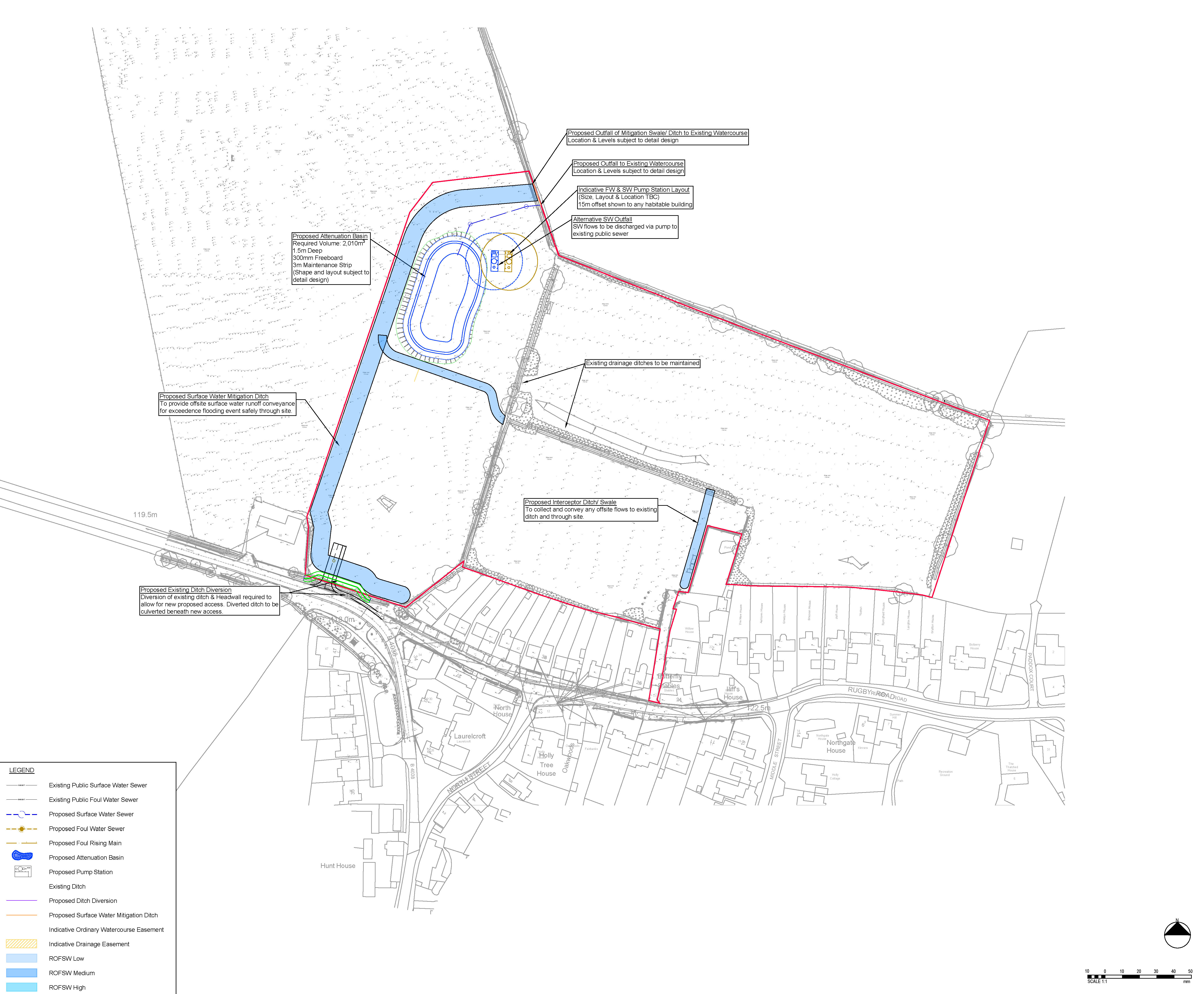
Drainage
The site is located in Flood Zone 1 meaning that it is within an area with the lowest probability of flooding at less than 0.1% each year.
As part of the drainage strategy covering the site, the proposals include an attenuation pond and additional Sustainable Urban Drainage Systems (SuDS) features to manage surface water and drainage risks. These features have been sensitively incorporated into the design of the public open space and to support the enhancement of local biodiversity. A comprehensive drainage strategy utilising sustainable drainage systems (SuDS) will ensure that surface water falling on developed areas is captured, treated and attenuated on site before being discharged at a controlled rate, which is set to ensure there is no increased flood risk on or off site.
Sustainability
The new homes will be designed to achieve the Future Homes Standard 2025, which will ensure they are all-electric, with high levels of fabric efficiency and powered by renewables. This will reduce carbon and energy bills for the residents, whilst also having a positive environmental impact.
- Energy efficiency and heat loss - Homes built to FHS must meet new requirements around energy efficiency. There will be stricter limits on heat loss with a focus on airtightness and improved insulation standards.
- Low-carbon heating systems - Oil and gas-fired heating appliances will be phased out in favour of electric heating solutions (air and ground source heat pumps), solar thermal or district heating solutions.
- Zero Carbon Ready - Homes should be built to enable the adaptation to zero operating carbon emissions without having to rely on future ‘bolt-on’ products once the UK’s grid is decarbonised.
- Carbon-efficient materials - Embodied carbon will need to be considered as part of design proposals.
- Smart technologies - FHS will also encourage the integration of smart home technologies. These systems could help homeowners manage smart thermostats, electricity generation from PV panels and water heating.

Have Your Say
Thank you, Feedback form is now closed.
Q&A
We understand that proposals like this raise important questions from the community. That's why we've included answers to some of the most common queries about the planning application.
No, the site is not located in the Green Belt.
Any planning permission is likely to be required to make financial contributions to local schools, healthcare facilities, transport infrastructure and utilities, if requested by the relevant bodies. The level of these contributions will be determined as part of the planning process and in consultation with service providers.
40% of the housing delivered as part of the proposals will be affordable housing, which is compliant with West Northamptonshire Council’s local policies. The mix and sizes of the homes made available as affordable housing will be determined during the planning process.
Affordable homes are homes made available via a registered housing provider for social rent, affordable rent, or intermediate housing, such as shared ownership or rent to buy, helping people on to the housing ladder who are unable to afford to rent or purchase a home through other means.
Vehicular access to the proposed development will be provided via a new priority ‘give way’ junction on Rugby Road (B4038).
A sustainable drainage system (SuDS) will manage surface water onsite to prevent increased flood risk to the site and surrounding areas.
The SuDS will be designed to accommodate a 1 in 100 year flood event, with an additional allowance for climate change. They will attenuate, treat and then release water into the existing network at a rate which is comparable to that which it is currently.
A Construction Management Plan will be agreed with West Northamptonshire Council to minimise disruption, manage vehicle movements, and control noise and dust. We would anticipate this forming a condition should planning permission be granted and details would be submitted to and agreed with the Council prior to work commencing on site. If permitted, working hours on the site will be controlled via planning conditions to ensure disruption is kept to a minimum. A safe and direct route for construction traffic movements will be agreed with the highways and planning departments.
Contact Us
If you have any comments or questions or would like a hard copy of any of our consultation materials, please contact us.
Send us a message and we will get back to you as soon as we can: